
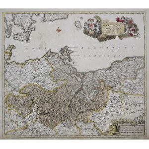
Marchionatus Brandenburgi et Ducatus Pomeraniae tabula quae est pars septentrionalis Circuli Saxoniae Superioris Authore F. de Wit Amsterdami
Copperplate colored engraving, paper; imprint: 52.7 x 61.7 cm, sheet: 64 x 54 cm.
The map comes from Frederick de Wit's atlas entitled: "Atlas, Tot Amserdam Bij ...", 1680.
Preservation condition: vertical fold of the sheet, minor stains.


Recently viewed
Please log in to see lots list
Favourites
Please log in to see lots list